A Coon Hollow Adventure
Preparing Coon Hollow for Rock Junction, 2014
April 19, 2014
By Jerry Smith
With Rock Junction looming only a little over a month away, (June 3, 4, & 5, 2014) pre-running the premier western Colorado and eastern Utah trails to ensure their readiness is necessary. Winters in this part of the world can be tough on our trails.
Members of the Grand Mesa Jeep Club had already reopened Granite Creek. After several years of neglect, the roadside brush had grown into the road making forward progress a paint removing process.
Cody entering the first major wash crossing.
The Calamity Mesa Loop had required moving large rocks and downed trees from the trail to allow “unfettered” access.
Next, the Coon Hollow Jeep Road would no doubt need some maintenance.
The Coon Hollow Jeep Road was reopened to full-sized vehicles in 2013 after many years of non-use by full-size vehicles.
You may read about that at: http://coonhollowisopen.blogspot.com/2013/06/Coon-Hollow-Jeep-Trail.html
You may read about that at: http://coonhollowisopen.blogspot.com/2013/06/Coon-Hollow-Jeep-Trail.html
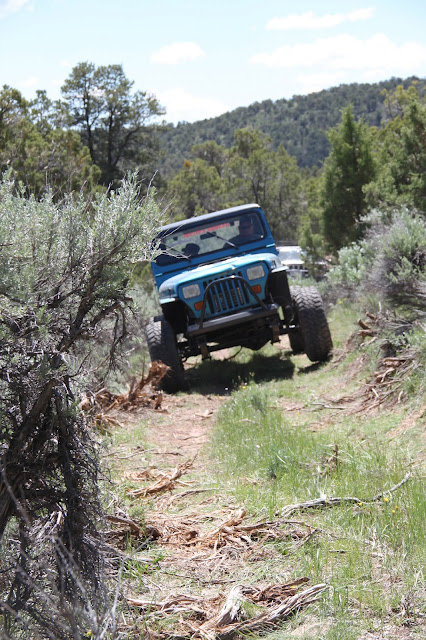
Tree branches, mountain ash, and sagebrush had overgrown the trail to barely leave room for ATVs to pass. Now, it allows access into an area with “Wilderness Characteristics”… funny how some people can ignore the presence of a road to fulfill their desire to name more “Wilderness”.
Removing some large rocks.
The winter of 2013/14 had been a long, cold, and harsh one. Erosion on other area trails had shown to be severe. With several deep washes to cross, Coon Hollow would no doubt need some tender loving care.
The morning of April 19th was somewhat ominous. Already raining, the forecast was for more rain. Much of the land north of the Colorado River is not conducive to wheeled travel when wet. The mud can be treacherously slick and even dangerous. Coon Hollow is north of the river.
The trip had been advertised to LEAVE from the Clifton “Albertson’s” parking lot. Albertson’s has not existed in Clifton for years. Confusion deluxe!
Not realizing the error at first, I sat at the City Market parking lot thinking that it was the correct place. At nearly 8:30, Greg comes driving up saying he saw Adam over near the former Albertson’s waiting… so we left for there.
Meanwhile, Adam had gone seeking any others hoping to go. Finally, the CB radio allowed all to convene and we dashed up I-70 toward De Beque.
After airing down in De Beque, we proceeded to the Coon Hollow road. Even though it had just rained, the road was only damp. Good luck was with us.
Entering the canyon, we noted several deep cuts across the road from erosion. Some were bone jarring to cross.
Coming to the first large deep wash crossing, Jerry led down the extreme grade into the wash. Bad decision!
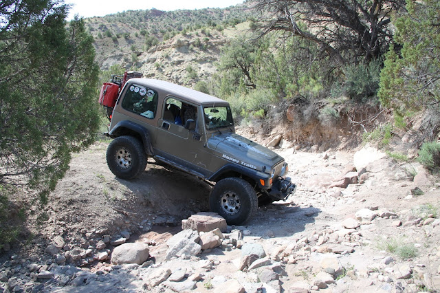
Jerry and Happy Trails entering the 1st major wash.
Jerry and Happy Trails exiting the 1st major wash.
The wash was nearly two feet deeper than the last time it was used and had exposed a substantial boulder in the bottom that was hidden from view over the hood.
The wet road surface disallowed any kind of stopping power and we ended up nose down in the wash up against the huge rock. Backing out was impossible without help. I should have looked this over on foot BEFORE entering! (a lesson I learned years ago and usually follow)
Greg’s winch was double blocked to the rear of Happy Trails and dragged her out with little trouble.
Looking the situation over, it was decided that a much larger crew would be required to “remedy” access through the wash. The only other avenue would be to scout another route.
Walking back down the road, we found access to and from the wash circumnavigating the former crossing.
Tim in a wash crossing.
The only reason we pursued this action was because this area is still considered “Open” by the BLM. If it had been managed under other circumstances, we would have been done for the day.
Soon we were back on the trail and wondering; “what’s next?”
Luckily, we found the road in fair condition clear to the top of the first shelf road. There, with the damp surface, the nasty off-camber turns entering the small canyon were going to be a bit of a challenge.
Jerry and Happy Trails on the entrance to the upper wash.
Tim showing some of the off-camber.
Dry, the corners are banked enough to slide you into the deep, rocky wash. Wet, well let’s just say there were new rules.
After negotiating the wash, it was on to the next shelf road section. This steep hill has many sizable rocks that you must crawl over. Some are large enough that if you aren’t careful, you will hang your axles on them. Again, add the mud factor on round rocks.
Todd crawling through the off=camber wash.
Todd crawling through the off=camber wash.
Soon we were traveling up the hogback ridge. Often, we stopped to trim Juniper and Mountain Ash from the road.
About half way up, the skies turned dark and began to wet everything. The road became slick in the extreme. Walking was tough while trimming.
About 500 yards from the top, the trail becomes quite off-camber and steep. The road by this time was saturated and treacherous.
Jerry finally spun-out and had to apply the lockers to continue. Adam and Greg were sans lockers and Adam spun-out about 2/3 the way up. This was a very bad situation.
The only sane (?) thing to do was to back down to where we could turn around. That, it looked like, would be dangerous and difficult. The cold rain coming down wouldn’t improve the situation any either. Hands and fingers ached from the cold before we were through.
The washes are deep and have extreme angles entering and exiting.
Some of the terrain is crazy cool.
Walking on the road was like walking on a steep, icy hillside. The only saving grace was most of the way; there was a small berm on the lower side of the road with thick brush growing from it.
We started walking Adam back down the hill. Every time he tapped the brakes, sliding out of control was all he could do until enough traction was found from the small amount of growth on the road surface.
Several times the Jeep slid nearly off the road toward the steep mountainside below. You could hear the seat covers ripping.
Finally, we reached Greg’s rig and started the whole process over with him behind the wheel.
Here you see the Grand Mesa with snow over the large burn area.
Way down the hill, a wide spot appeared and we turned Greg around. Back up the slick road we mushed to Adam’s Jeep. It was like “Peat and Repeat”.
Then it was trudge back to Happy Trails, about a quarter mile up the hill. All this walking on the rain-slickened road was getting very hard on a guy who just weeks ago had open-heart surgery.
At Happy Trails, it was decided that I would drive up to the top to gauge how much further it was. Greg and Adam were willing to walk up if it wasn’t too far.
By the time I could see the top and get turned around, they were nearly caught up to me. We continued to the top of the saddle where the views are tremendous. This is where I made another mistake.
Down the other side, the road normally takes you to a great lunch spot. I thought about driving down to it. BAD idea!
From the "Lunch spot", the burn area above the natural gas well and beyond.
Just a few yards down the hill, it was apparent that the only “down” was down the steep hill… off the road sliding sideways.
The only option was to tie the winch line to a small Juniper above the road and swing the rear downhill. Then winch back up to the road where we could switch the anchor to another tree and begin turning back onto the road.
Luckily, this plan worked perfectly and soon we were on the way back down to the other Jeeps. Going down forward was much easier than backing.
A late lunch was held before we headed out. Coon Hollow is one-way in and out. The look of the trail is dramatically different going down than going up though. It’s like two different trails altogether.
Going up, it’s like looking through a tunnel of trees. Descending, you can see the panorama of the entire canyon and town of De Beque and the Battlement Mesa behind. Gorgeous!
The Coon Hollow Jeep Road will require a heap of work to allow continued access for the foreseeable future. The wash will likely require a rock dam be built below the road with some screen to catch and hold sand and silt. This will allow the road crossing to be raised to a level of usability again.
Until that, the bypass will have to suffice.
Despite the difficulties, this day turned out to be quite an adventure for the three brave hearts. A ton of work was performed and some new experiences had. We look forward to doing it all again.
One last thing we have to cover; “When you come to a fork in the road… take it!” Who knows? You might find another gem like this one.
Many Happy Trails to and for you.
NOTE: Most of these pictures are from several different trips up Coon Hollow.
NOTE: Most of these pictures are from several different trips up Coon Hollow.
Copyright Happy Trails 4wd 2014. All rights reserved.


